As the title suggests, there was a bit of a surprise in store for the riders at the 4 am riders meeting.
Before I went to sleep last night I got my routing workstation set up and ready for the task that would follow the riders meeting the next morning. Jumping up to the 3:30 am alarm, I slipped on my checkpoint clothes and headed downstairs for a quick breakfast and staked out a place in the lobby for the meeting.
At precisely 4 am, Route Master Jeff Earls climbed up on a step stool and dropped the bomb that there would not be a Leg 3 in this year's rally and that all the information needed for the remaining 7 days would be in the rally packet. Returning to Kennewick on Sunday night (as previously described as checkpoint 2) would be entirely optional. However, in order to NOT return to Kennewick riders would have to either 1) collect a bonus north of the 60th parallel, or 2) collect both the CAPED and ROSIE bonuses prior to the finish in Greenville, SC. What???!!! Also, the McKenzie Pass bonus would be worth 0 points as it was closed due to snow. Rally packs were then distributed and the mad dash back to our rooms commenced.
First thing after getting back to my room was to get the electronic files from my email. When I logged in, there was no email!! Oh crap, am I having a problem with my email? After 10 seconds that seemed like 10 minutes, the email popped up in my inbox. OK, this rally pack is a lot thicker than Leg 1. Whereas there were only 70ish bonus locations on 26 pages on Leg 1, this time there were nearly 200 locations with numerous combination bonuses thrown in. After pasting in the bonus list I had to hand enter all of the point values. Then remembering that the coordinates supplied in the electronic files didn't necessarily correspond with the actual bonus location, I set about going through the entire list and hand entering the adjusted coordinates (really, really dumb move). This, of course, took nearly 2 hours. In highsight I should have laid down a base route then adjusted only those locations I planned to go to.
As I'm importing the edited bonus list into Basecamp I start hearing motorcycles firing up and riders leaving. Panic level rises as I scan the map and try to make sense of it. Alaska is out of the question for me as I'm trying to be somewhat conservative. That means I need to plan to return to Kennewick in 2.5 days for the massive point value associated with it. Thus the reason for referring to this Leg as 2a. It simplified my list to what I could reach and get back to the "checkpoint". (More bikes fire up and tear off)
By now I'm overwhelmed with my options and settle on a route to northern California and down as far as Alice's Restaurant before turning back north. Little did I know that I would hit most of my route but nowhere near the same order. About 9:30 am I said enough and start loading the route onto my gps units. The Zumo loaded right away with no problem. However, I couldn't get the Dezl to recognize the route. WTF?? Fiddling with it for 10 minutes I had to let it go and move on to the iPad. What? It won't take the bonus locations? What's going on? Ok, I have to leave and I need to leave now so I'll have to work with the Zumo until I can figure out what's going on with the other two units.
 I'm packed up and heading out of the parking lot about 10:15 am and notice that the lot is awfully empty. Ugh...not a good start to Leg 2. I'm frustrated with my tech gear and just don't have my head on right. Tracking down into Oregon I focus on my first bonus, Smith Rocks, just to get my head back in the game. Captured I continue south and stop in Madras for some lunch and re-focus.
Back on the bike I begin thinking about my next bonus, MCKEN. Not thinking real clear I didn't make the connection that it was McKenzie Pass which Jeff Earls had announced as worth 0 points. Being somewhat familiar with the Redmond/Bend, OR area due to repeat visits to Sunriver Resort, I had a vague idea where the bonus was. Cutting through back streets of Redmond I jumped on the McKenzie Hwy heading towards Sisters. Thinking about my tech issues I totally blew by the turn to the eastern approach to McKenzie Pass and continued westward. By the time I realized my mistake my Zumo was insisting that I continue forward and basicly ride around Mt Washington and make the western approach to McKenzie Pass. As I reached the turn off, I was greeted with a very dubious looking gravel road. The value of the bonus just wasn't enough to endure miles of gravel road so I made the decision to move on. At no point during this entire escapade did it ever hit me that I was chasing a 0 point bonus. What a dumbass!!
My next planned bonus was Crater Lake but that would mean that I would have to go back eastward to US 97. Since my plan had me returning on 97, I decided to try and capture it on the way back north. So based on my current location it was better for me to continue west and catch I-5 and head south to California. By now I was totally disgusted with myself and really starting to question my ability to finish this rally. Out of the blue I get a call from Dave Arkle. He had helped me before the rally with a mechanical issue so I started to unload on him about all my screw-ups and trouble with my gps units. Thank God that Dave let me vent and he calmly got me back to working the problem. This took a while and slowly I settled down and got back into the game. Dave recommended that I stop at the next convenient McDonalds and take the opportunity to get on their wifi and to try replanning my route and reloading the gps units. Agreeing to follow his suggestion we hung up and I was feeling better. Not two minutes later I'm dropping down a pass in northern California at sunset and off to my left is the most brilliant display of Mt Shasta imaginable. The sun was hitting just the mountain and it was a golden fire in color. Just stunning and one of the most pleasant parts of the entire IBR to have the privilege of experiencing it. The picture below is similar to what I saw.
 |
| Copyright: Pictorem.com |
A few miles further I exited the highway and did as Dave suggested and pulled in to a McDonalds to replan this leg. While wolfing down a burger the points on the map started to line up and a plan came together. The new route promptly loaded onto both gps units with no hiccups. I didn't bother with the iPad so all was well and I felt a whole lot better. This was going to be an OK leg.
Fortunately, I was at the exit I needed for heading into the remote Northern California wilderness to capture the Forks of Salmon bonus. As I turned west onto Sawyers Bar Rd, the last rays of the sunset started to fade.


The road narrowed down to a single lane as shown at left. No guard rails. No markers. Just every lumen that my motorcycle could muster to light my way. Others made this 40 mile trek in the daytime and said it was very nerve racking. And, here I am doing it in pitch darkness. In hindsight it may have been beneficial that I couldn't see all the dangers which helped me stay focused on the road. (btw, can you believe that Google Maps has a Street View of this road?)
 I reached my destination 2 hours later. The Forks of Salmon Post Office is in such a remote location that they do not have electric service to the building. When the postmaster needs to use the computer, she has to fire up a small generator to provide the necessary power. When I turned my motorcycle off and looked around, I could not see a single artificial light anywhere. Only the stars provided any sort of illumination. As I was admiring the sky, I got an itchy feeling that something could be watching me. Yeah, I'm dead smack in the middle of mountain lion and bear country and I'm gazing at the stars. I quickly made ready to go and fired up the motorcycle to hopefully scare away anything that was higher in the food chain at the moment.
 Now my quest was to get back to civilization and find a hotel. I was in the window to collect the Leg 2a Rest Bonus and was really looking forward to it. Leaving the Post Office I continued westward on Salmon River Rd. This road was also a single lane variety only much worse. Parts of the road had slid off into the river and the highway dept had only installed 2 small posts at each edge of the road. Being only about 5 ft wide, I could squeeze through but I don't think a car would make it. No sooner had I made through that bottleneck, a skunk decided that he would jump out into the middle of the road and lead me down the mountain. What do you do when you're on a single lane road following a skunk taking a late night jog down the lane? You let it!! After about a 1/2 mile the skunk decides he's had enough exercise and turns off into a gully. Whew. That woke me up a bit.
Just before midnight I completed the 16 mile run in a swift 45 miles (not!) and got back to a real road and headed towards my planned stop in Arcata, CA. Grabbing a receipt to start my bonus at a Chevron, I pulled into the Motel 6 to check in. Oh boy, there sure are a lot of motorcycles in the parking lot. Turns out a outlaw m/c club was staying the night and 2 prospects were roaming around providing security. We chatted for a few minutes and they said they would make sure nothing happened to my bike. After a quick shower it was off to bed about 3 am. Total miles for the day was about 740. Not bad given my late start and too frequent long stops.

Day 6 - Arcata, CA to Fortuna, CA
This would turn out to be the most interesting day of the rally for me. I got to experience more variety in scenery than one can imagine. The main focus of the day was to reach Alice's Restaurant south of San Francisco during a very short time window in the afternoon. I needed to have my picture taken with a veteran IBR finisher and he was only at the bonus from 10am to 2pm.
Knowing last night that I needed to allow for time getting through SF, I cut my rest bonus to the minimum of 4 hours and got back on the road south. It finally dawned on me that I would be on the famous Pacific Coast Highway (CA-101) for most of the day. Parts of the road was a divided 4 lane, others a simple 2 lane highway, and some parts narrowed and slowed down to a slow speed lane that weaved its way through the magnificent redwood forests of northern California. It was turning into a really warm day as I approached San Francisco.
Checking my time I stuck with the plan and exited the highway at the north end of the Golden Gate Bridge to capture the Pt Bonita Lighthouse bonus. There were several other IBR riders at the bonus at the same time. We all arrived within minutes of each other. This bonus would prove to be the most physically challenging bonus of the rally. From the cliff top parking lot it was a 3/4 mile hike down a trail to the Lighthouse located near the water level. Going down was a bit rough on my bad knee. Reaching the objective, I needed to capture 2 photos per the rally book requirements. The first was of the large metal door leading into the base of the lighthouse.
The second was an attempt to capture the Golden Gate Bridge from the lighthouse location. Of course, there's some fog to deal with but you can just make out the bridge in the background. Now it's time to climb back up the trail. Here's where my total lack of conditioning takes it's toll. The other riders had long since left by the time ol' fat boy reaches the parking lot. To make things more interesting, my trusty old riding boots give up the ghost at this point and split open. Great.

| 
|
Now I needed to reach Alice's Restaurant which is south of San Francisco. I do my best to cross the Golden Gate and deal with traffic on the way to the bonus. I pulled over and made my Call In bonus successfully and continued south. Exiting I-280 at Woodside I sighed relief as I knew that I would make the bonus window. Pulling into the parking lot, there were motorcycles everywhere along with anything you could imagine as far as exotic cars. I even saw an uber-rare Ford Pantara. Several other IBR riders are there including my friends Lisa Rufo and her father, Martin Cover.
 Walking up to the front of the restaurant I'm met by Jerry White who congratulates me on making the time constraint. Per the requirements of the bonus, I have my picture taken with Jerry. While I had my helmet and jacket off, I took the opportunity to break out my computer and look over the rest of my Leg 2a route while drinking prodigious amounts of water. My plan was looking good. I'm packing up just as 2pm approaches and an IBR rider pulls into the parking lot and runs for the front of the restaurant. Jerry announces that he had just made the cutoff by 15 seconds!!
Leaving Alice's Restaurant, I miss a turn and end up descending the mountain on a seriously twisty road that took FOREVER to complete. I wasted at least an hour trying to get back to I-280. Back on the highway heading north I need to transition San Francisco again and go north on the Pacific Coast Highway (basically retracing my steps earlier in the day). As traffic became more and more congested, I made a move that I swore that I'd never do. I inched over to the line diving the far left and the middle lanes of the highway and proceed forward between the cars. Halla-freaking-luya!!! You would have thought the Red Sea parted as the cars and trucks instinctively moved over in their respective lanes to make room for me to slowly pass. Holy cow, it was beautiful. When necessary I repeated the maneuver several times until I reached the Golden Gate Bridge and traffic thinned out. Oh what a time saver!!
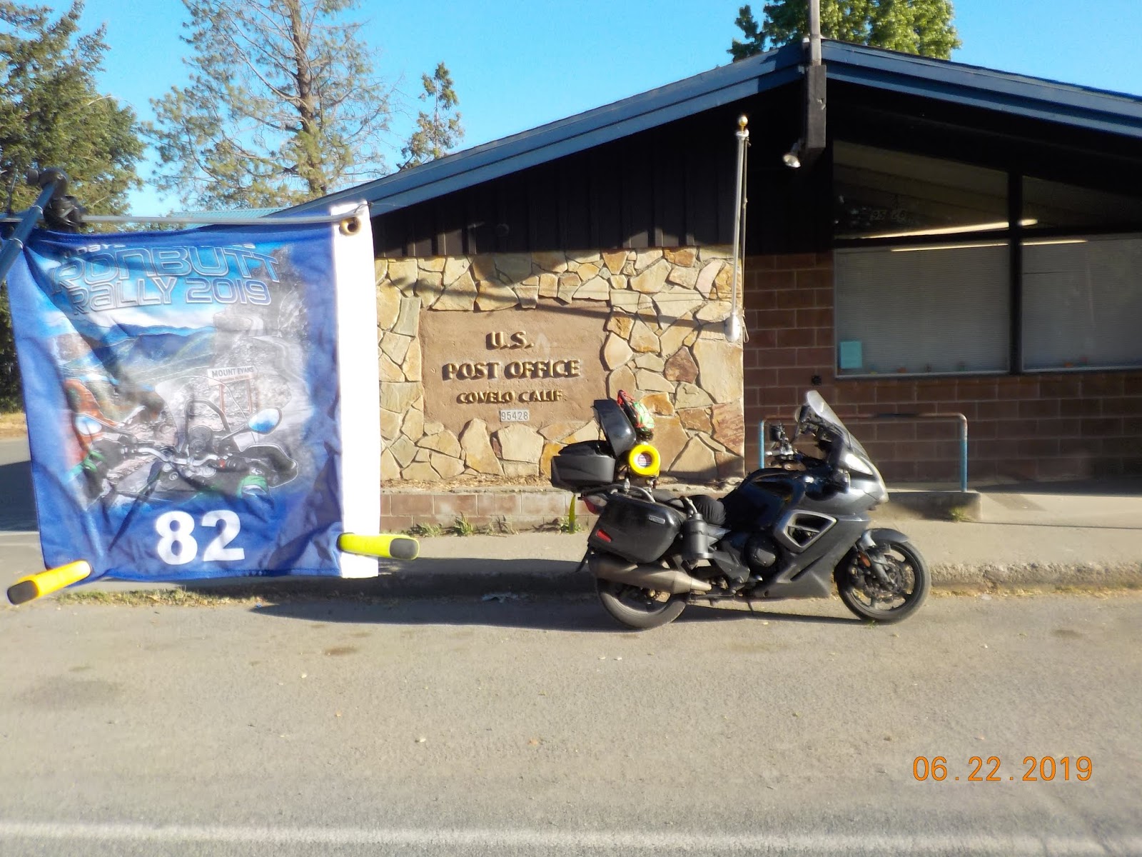 Free of the urban area I'm back again on the PCH making good time heading north. Energized by my positive experience lane splitting, I really am enjoying this day. Miles north of San Fran I exit the highway and take to back roads to capture the bonus located in Corvelo, CA. It is a remote town that sits in a small valley deep, deep in the backwoods of the state. The town is surrounded by mountains on all sides and reminds me somewhat of Burkes Garden in Virginia. The heat is starting to suck my joy out as I make my way back out to the PCH to continue north into hopefully cooler temps.
The Garmins have me exit the PCH in the Humbolt Redwoods State Park in order to take the road out to the aptly named LOST bonus. The Mattole Campground sits on the coast of California and claims to be the most remote part of the state. I believe that their claim is true. The rally book warns that the roads are in rather poor condition and I can safely say that was the understatement of the year. Like the previous night, the last rays of the sun pass as I cross under the PCH onto Mattole Road and head west. The pristine asphalt weaves its way between enormous redwoods and betrays what is to lay ahead. As I exit the forest the road condition deteriorates rapidly. Patched asphalt turns to limestone gravel with pot holes that could swallow a bus and bumps that threatened to toss me and the bike over the cliff. I cannot explain in words how bad I was being tossed around. This goes on for 40 miles into the wilderness. I keep noticing large boulders across the middle of the road like they were put there to keep cars out. Really out of place and is freaking my out by now. (Little did I know that I was riding over the epicenter of a 5.6 earthquake when it happened)

I'm again relying on my lights for the only illumination in the area as it appears that the electricity is out at the various homes that I pass. Approaching the turn to Lighthouse Rd the local fire station is also blacked out. Weird. As I make my way to the campground I pass the shell of an old school bus with a big For Sale sign painted on it. Must be California. I reached the campground and captured the bonus photo of the campground sign. It is pitch black and I can hear the roar of the ocean hitting the beaches below in the darkness.
Heading back out of the campground I reached Mattole Rd and a decision point. Do I go back the familiar way for 40 miles to the highway for a 65 mile trip to my hotel or do I take the left turn on unfamiliar territory for the 50 ride to the hotel? Looking at the pristine pavement leading off to the left, I decided to give it a try. In all my motorcycle riding years, I would not face a more terrifying ordeal than what I am about to experience. Words cannot describe the fear and desperation to make it through to the other side. I'm tired. I'm alone. It's pitch black. And I have little idea of where I am.
 Mattole Rd passes through the small village of Petrolia and turns towards the coast. Don't let the picture at right fool you, the pavement was no where near this condition. Breaking through the coast ridge I was met with gale force winds coming off the ocean and was blown to the edge of roadway several times. I'm only going about 30 mph as it was the max that the wind and the road conditions would allow. Without warning the roadway would turn to the same limestone gravel that I experienced earlier in the night. I approached a one lane bridge over a river outlet and literally had to duck walk the motorcycle across to keep from being blown over the side.
As I reached the northern edge of the coastal section, the road made a sharp 90 degree turn and started up the hill. Being only able to see a few hundred yards in front, it was difficult to make out the series of switchbacks that I would encounter over the next 15 miles. On a steep 10% uphill grade, the pavement gave way to the most awful section of limestone hardpack imaginable. I'm standing on the pegs trying to control the beast. Swerving from road edge to road edge in the dark with a large unguarded drop off to my right, I notice a pickup making its way downhill. The good samaritan stops and pulls over close to the side to let me have as much room as possible. The gentleman shouts, "You got it, boy. Good luck!!" as I pass him. I really needed that encouragement to make it the next 1/2 mile to the summit.
Reaching Ferndale, CA the roads got back to normal and I made my way to Fortuna where my hotel bed was waiting. I had missed my chance to improve on my rest bonus as I arrived at the hotel after midnight. Knowing that the next day was important to make it back to Kennewick by 8pm, I settled into bed after a good shower for a quick 5 hour rest. Today's effort netted out to about 750 miles and a lifetime of experiences.

Day 7 - Fortuna, CA to Kennewick, WA
Today's goal was to capture the one remaining big bonus in the area and start making my way back to eastern Washington. It was imperative that I reach the "checkpoint" hotel by 8 pm in order to capture the massive amount of points associated with it.
Heading out a little after 5 am, I made the short ride south to the turn off to CA-36 for the 100 mile ride east to the HYAMP bonus. To reach the bonus there is a northern and a southern approach. I had heard that the northern approach was terrible so my plan was to use the southern approach. Heading east into the rising sun I was immersed in beautiful California back country. Passing a small country store I caught a glimpse of a motorcycle parked in the shade. About 20 minutes later Wolfe Bonham comes roaring past me and makes short work of the twisties and disappears into the distance. About a half hour later I noticed Wolfe laid back on his bike catching another quick nap. Not long after I get the nods and have to pull over. Wolfe leapfrogs me again while I'm resting.
 Nearing the turn off on CA-3 for Hayfork, I passed through another grove of majestic redwoods. What a sight to behold. Little did I know that Wolfe had pulled off into the trees for another quick cat nap. I turned north on CA-3 and made it to Hayfork for the turn back west on Hyampom Rd for the 22 mile ride to the bonus location. The road was quite twisty which kept speeds down below what Garmin said the pace should be. Reaching the Hyampom General Store, I snapped my picture of the store sign and decided to close my eyes for a short rest. Not 10 minutes later a local rides his bicycle up and starts chatting. Obviously there's not a lot of conversation going on in Hyampom because this gentleman was going a mile a minute with his rambling. Resigned to the fact that he wasn't going to leave me alone I start making my way back to the bike. At that point the gentleman trundles off on his bicycle just as Wolfe pulls into the parking lot. Surprised that I had passed him again we chatted for a few minutes before I took off back down the 22 miles to Hayfork.
Back out to civilization I continued east on CA-3 to Redding, CA where I picked up I-5 for the ride north near Mt Shasta. At Weed I took the exit to US-97 for the trek north across Oregon. Reaching Klamath Falls, I needed something to eat and remembered that I could collect an "R" bonus receipt here. It was again a warm day so the stay at the McDonalds lasted a bit longer than planned as they had the a/c cranked down low.
Concerned about time I hopped back on the bike and continued my journey north. The Garmins are showing an arrival approximately 7:15 pm which was cutting it closer than I wanted. I toyed with the idea of making the run up to Crater Lake but I simply didn't have the time. Around Bend, OR another IBR rider caught up with me and we stayed together as we wove through some of the small towns. Not much later I spied Wolfe Bonham again catching up to me. We let Wolfe take the lead and we made pretty good time the rest of the way up to our turn on I-84 at the Columbia River. I saw Wolfe turn off for some gas and somewhere along the way I lost the other rider. I had enough fuel to make it back to the hotel so I continued on. I rolled into the Hilton Garden Inn in Kennewick approximately 7:30 pm. IBR Staff said to just park and go inside to check in with Lisa Landry.
 |
| Credit: Tobie Stevens |
Not a terribly productive day but I did what I had intended. Total mileage was about 715 which would be my shortest day of the rally. After eating a quick dinner it was upstairs for a shower and to plan out my Leg 2b. Looking at my current points, I was able to lay out a very manageable plan to reach finisher status with about a 10% cushion. I finally laid down about 10 pm for some much needed rest.

No comments:
Post a Comment