Tuesday, July 31, 2018

Butt Lite IX Recap - Day 5 - Rejuvenation

Day 5 (July 12) started in the wee hours after a good 8 hour break. The hotel host was fantastic in helping me get ice and fresh water in my hydration jug and an apple to get me going.  Unfortunately, since I had booked my stay through Hotels.com (Expedia), he said that he couldn't print me a receipt.  Geez...another receipt challenge.  Rather than waste time as I was unsure of my rest start documentation, I set out to find the 24 hr McDonalds I spotted on the maps last night.  Slamming a couple of McGriddles in my jacket pocket and putting my receipt away, I set out heading back east.

My revised plan was not going to score me big points but it would keep me busy for the next two days.  Today I would cross back through Kentucky entering Virginia and finally stopping for the night in Johnson City, TN. This would set me up for a nice ride to the finish on Saturday.


Into the rising sun I traveled on Illinois SH13 until crossing into Kentucky on SH56.  Thank you, Lord, for the noticeably cooler temperatures.  This is going to be a good day.

Slogging past the maze I encountered yesterday trying to get out to this highway, I passed into Kentucky and swung around Owensboro where, surprisingly, I then crossed over into Indiana.  The ELC bonus was a memorial to the passengers who perished aboard a Lockheed Electra in 1960.


At this point I was coming alive again rejuvenated by the cooler temperatures. Passing back into Kentucky is was short work to make my way back down to the Mammoth Cave National Park and my next, and arguably, the most unique bonus of the rally.

The Green River Ferry is touted as the shortest ferry ride in the world.  Linking parts of the Mammoth Cave National Park, it is maintained and operated by the Park Service.  A maximum of 2 vehicles can fit on it at any one time.  While the Rallymasters allowed us to take a picture of the ferry while waiting (motorcycle, flag and mid-river ferry had to be in photo), we had the option of taking a picture of your motorcycle ON the ferry while crossing.  It was quite the challenge to park, hop off the bike, pull out the rally flag and camera, snap the picture in the middle of the river, stow everything back, and remount the bike to be ready to exit all in the span of about 60 seconds.


Some of the many Barrel Houses at Heaven Hill Distillery
To say that Rallymasters have a devious, sometimes cruel streak is somewhat of an understatement.  Had they know how much I love whisky, they would not have included the next bonus.  In Bardstown, KY is located the Heaven Hill Distillery where several brands are produced including Evan Williams and Elijah Craig (YUM!!).  Our task was to purchase an item from the visiter center and have the item and receipt presented at scoring.  I purchased a small container of Evan Williams Smoke Garlic Salt for the rally and a bottle of Elijah Craig Small Batch (94 proof) for myself.


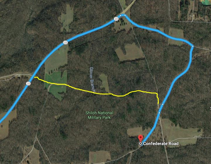
Next up was the WLD bonus located in the Daniel Boone National Forest.  This proved to be one of the most challenging bonuses to collect.  The rally book clearly states that the last 2.5 miles to the bonus is a "narrow, one-lane gravel" road.  Apparently, Garmin didn't get the message.  In the map shown from Garmin's Basecamp route planning tool, my arrival to the area was from the NW (upper left) corner (follow the red line).  After passing through the small town of Livingston, the Garmins emphatically tell me that I missed the turn.  I'm thinking what turn? I didn't see a road.  I u-turn and go back to the point where a small, and I mean almost unnoticable, gravel road heads down the trail to the river.  Ok, we are supposed to take a gravel road to this bonus so there I go.  It becomes very apparent very quickly that this ain't going to go anywhere but straight into the river!  Later I learned that there was once a low water crossing at this location but it had been washed out decades ago, however, the County still has it recorded as a county road.  Garmin interprets it as a 55 mph road.  With no room to turn around on the downhill road, I am forced to go all the way to the waterline before I can attempt a turn around.  Parts of the 20 point turn had my rear wheel slipping into the river.  I'm not amused at this point.  F*n Garmin.  ***somewhere in the back of my mind is the mantra, Don't Always Follow the Magenta Line.***

Escaping from this trap I stop at the highway and fire up the iPad and CoPilot to get my bearings.  I see an alternate approach (blue line) to the bonus a little further to the south so I take off that way.  Sure enough the Garmins pick up the change and route me properly to the bonus which is the Camp Wildcat Battle Monument.  The last 200 yards into the bonus is nice, fresh asphalt leading to a new looking monument area. Our task was to answer a question from one of the interpretive signs.  Done.  Now looking at the Garmins, I see that they are trying to route me out in a direction that simply does not exist!  Being a little wiser at this point I head out the way I came in and would deal with the rerouting once on the highway.  This bonus cost me about 45 extra minutes that I really didn't have that day.

Thankful to still be upright, I headed off to Jackson, KY for my next bonus, a historical marker dedicated to some really angry people following the Civil War.  The marker states that probably around 100 county officials were killed in the time between 1870 and 1920.


Continuing my eastern trek the next bonus was fortunately right on my path and was easy to get to.  The Battle of Middle Creek where a young Col. James Garfield would elevate his stature by leading his Union troops to a victory over the Confederates of eastern Kentucky. This event launched Col Garfield on his path to the Presidency of the United States.


The next bonus was special in a personal way.  If you recall the TV mini-series "The Hatfields and McCoys", the feud between the two families started with the trial of Floyd Hatfield for stealing one of Randolph McCoys' hogs.  The trial was presided over  by Judge Preacher Anderson Hatfield. Long story short Floyd Hatfield was acquitted and everything spiraled out of control from there.  My In-laws were raised in nearby Williamson, WV and some family had married into the McCoys.  Our bonus was to photograph the Hog Trial Site marker located at the log structure where the trial was held.

Heading south on US 119 through the long ridges of the middle Appalachian Mountains the roads became decidedly more twisty.  While a whole lot of fun to ride on, they don't really help when you're on the clock in a rally.  Passing through Pikeville and Cumberland, KY, I finally reached the turn off to Lynch, KY where my next bonus was located.  Lynch was a company town where the coal mine owners owned everything, including the housing.  Workers had to "rent" housing from the company, purchase food from the company store, etc.  Even the local police force was run by the company. Their main job was to deal with workers trying to unionize the mine.   The bonus,  P31, was to take a picture of the Portal 31 entrance to the mine which is now a tourist attraction.

The Trail of the Lonesome Pine
My last bonus of the day was a mere 18 miles away in Big Stone Gap, Virginia.  However, it would take nearly an hour to traverse the ridges on the way.  The route is known as The Trail of the Lonesome Pine and it lives up to its name.  It seems like you are hundreds of miles away from civilization.  Beautiful but isolated and a major time suck.


Arriving in Big Stone Gap I collected my bonus and started looking for some hotel options.  I was going to be able to make it to my planned stop in Johnson City, TN but would be a bit behind schedule.

I needed to make sure that this was an 8 hour stop in order to maximize my rest bonus points.  I just was not confident that I had good receipts from last night so I made sure that I got good ones tonight.  The clerk at the Best Western gave me a check-in receipt that had the proper timestamp on it and he assured me that the check-out would also have a good timestamp.

After lugging my gear up to my room I ventured down to the attached Chinese restaurant in the hotel. Risky, I know. But I was too tired to go anywhere else.  As I'm eating my dinner a couple walks up and starts asking me about my bike.  It turns out the hotel is hosting a Women's Motorcycle event that weekend.  They are very nice and quite interested in what I'm doing on this rally.  I do the best I can but I have to finally tell them that I have to get upstairs to bed.

Ah, a shower.  A nice relaxing shower.  Today has been a good day.  I captured everything that I had planned for.  Started my learning on not to blindly follow the _____ magenta line (not entirely learned yet).  I'm asleep before my head hits the pillow.

Points collected today:  3502.  I'm ok with that.

Day 6 coming up...


Saturday, July 28, 2018

Butt Lite IX Recap - Day 4 - In My Head

There's no harsher critic of me than me.  The tapes never stop.  My rally was over at this point.  I was faced with two choices: 1) ride a simple route for the next 3 days and collect my finisher status, or 2) challenge myself and go for the best route that I could.  69th place was a long way down to start from.  Ah hell, the hyper-competitive spirit in me said to take option 2.  So up at 5:35 I head downstairs to get some breakfast and my rally pack for Leg 2.  For those of us that checked-in prior to midnight last night were to get a prize of 2 full hours of off the clock planning for Leg 2.  This is unusual and a real gift.  A LOT of the riders took advantage of this prize.

Promptly at 6am, the Rally Staff begin to hand out the numbered rally packs.  As in the first leg, everything including the envelope is required to be turned in at the finish back in Lexington, KY 3 days from now.  Now the hustle back to the room to start the planning process.  Fortunately, the rally had occupied the entire hotel so the stampede down the halls was not affecting regular travelers.

Once in my room I transferring the necessary files to my iCloud drive and first imported the raw GPX into Basecamp to get an overview of where we would be heading.  As expected, we would be mostly in the NorthEast and MidWest.  Unknowingly repeating my mistake from the first leg, I open the TXT file and proceed to work through the rally book to add the availability codes to the boneses.  Another 45 minutes wasted.  Once I had on the bonuses coded, I reloaded them into Basecamp to see what options were available.  Obviously, the big points were going up into New England but there was this arc of big money points across northern Minnesota and the UP of Michigan.  Since I wasn't going to have a competitive finish anyway, it was an easy choice for me to go the western route and avoid all the headaches of the northeast.

It turned out this route was very similar to fellow Trophy rider, Rick Armour, but in the opposite direction.  Whereas he went due north up through Michigan and circled back in a counter-clockwise pattern, my plan was to head west then north and move in a clockwise pattern.  Day 4 was going to be weak on points but Days 5 and 6 were loaded with big bonuses.  I was looking at 3,135 miles and a bounty of 15,398 points.


My planning was interrupted for a mandatory riders meeting at 8:00 where we were advised once again to not just follow the magenta line.  Apparently, a LOT of riders were experiencing less than perfect road conditions by not paying attention to where they were. After the short meeting was over we were free to leave the hotel and start Leg 2.  I still had not finish my prep so back upstairs I went.

With my route set and the Garmins loaded, I again had trouble loading my bonus locations into CoPilot on my iPad.  This was a real pain point and caused me a lot of grief.  However, I couldn't waste any more time on it so it was time to dress, pack and go.


I don't really recall but I believe that I left the checkpoint hotel about 9:45 am, a bit later than I intended.  I was not feeling 100% recharged and the day's heat was already setting in.  I slipped through Knoxville with no problem and exited a few dozen miles later to claim the UTO bonus. Oh, and notice that I corrected the date on my camera.

This is where the difference in a 32/36 hour rally and a multiday rally shows itself, my next bonus was 276 miles and would be the first of 2 such long stretches planned this day.  Slogging down the Interstate lets the mind wander to things that it doesn't need to, like trying to figure out where my Leg 1 bonus photos had disappeared to. What action did I do that led to that happening? I was very losing my focus so I called Karen hoping to take my mind off the Leg 1 disappointment.  We were discussing my route and I told her that I would be heading up through Illinois, Missouri, Iowa and Minnesota today.  She asked if I knew that there were heat advisories in that area for today. About that same time an alert popped up on my Garmin Dezl about the heat advisory.  And it would pop up again every 20 minutes to remind me of what I already knew, it was f'n hot today.

Now late in the afternoon I finally approached my 2nd bonus, CIR, which is a ferry crossing of the Ohio River between Kentucky and Cave In Rocks, Illinois.  Fortunately,  I didn't have to wait long as the ferry arrived on my side in short order.  To capture this bonus you were required to take a photo of your motorcycle on the ferry, with you flag displayed, in the middle of the river during the crossing.  Of course with the moving ferry, the flag was not wanting to cooperate.

It was kinda cute how the little pilot house would rotate 180 degrees once the barge pulled away from the shoreline.  After crossing I stopped to document the bonus and started searching for gas as I was getting quite low and hadn't anticipated the remoteness of this stop.  About 10 miles ahead was a station so I made my way there.  Holy cow, I knew Illinois gas was high but $3.29 a gallon for regular?

After filling I set out for a big value time restricted bonus called the Garden of the Gods (COG) that was about 20 miles away.  There just wasn't a good way to get there.  Each Garmin was giving me conflicting directions.  After finally arriving I snap pictures of two different markers that had "Observation Trail" on them.  After the fiasco of the Old Trace bonus on Leg 1 I was playing it safe that one of these had to be the right one.


Leaving the state park, the Garmins were doing their thing again and trying to route me done 55 mph gravel roads. Ugh, this was getting old.  Trying to get to SH13 was proving to be a major time suck.  I'm sure I spent 20 extra minutes going back and forth on unmarked county roads trying to get out.  One interesting tidbit was that I passed this young bearded nature boy looking dude flying his drone just off to the north.  When I rounded the corner I realized what he was doing.  He was spying on a large strip mine/quarry. Not right, dude. Not the intended use of a UAV.

Finally turning west onto SH13 into the blazing setting sun, I made it into Harrisburg and continued on to Marion where I stopped for some dinner.  Ah, the air conditioning.  It was like 98 degrees outside and just that kind of oppressive heat that it sometimes gets.  I'm facing another 250 mile slog including passing through St Louis so my mind starts playing with me again.  I've done just over 500 miles today in the heat and I have at least another 375 to my planned stop.  There's just no way I can do it safely so I make the call that I'm done for the day and decide to book a room in Marion and replan the rest of the Leg.  What a wasted day.  3 bonuses, 500 miles and only 967 points.  Pitiful.

Based on my prior experience I went straight to the hotel hoping that they could give me a good rest start receipt.  There was a pilot nearby but they are notorious for not being a good DBR.  The hotel was proving to be a problem as well.  Based on the way that I felt, I really didn't care at this point and heading inside for a shower, some planning time and bed.

After looking at my options, it seemed like the best bet was to backtrack through Kentucky into Virginia, North Carolina and back through West Virginia on my way to the finish line.  Not the highest point total but the bonuses were fairly close together and moderate point values.  With the route laid out and loaded onto the Garmins, I hit the sack.

I wrap this day with probably the hardest, most difficult to accept:

Lesson Learned:  Conditioning matters.  The first IBR finisher I ever met was Eric Bray at Mortons BMW in Fredericksburg, VA about 5 years ago.  I was just getting back into LD riding so the questions flowed.  The first thing he said about doing the IBR was conditioning.  Conditioning was the key.  Of course, I blew that off as any fat boy would do. Now I know why.  It's a very difficult thing to accept when you're a fat boy.  I've got to do something to improve the situation prior to the IBR.  Eric is a Navy man and is in impeccable condition.  I see posts of Jim Owen riding his bicycle everywhere.  Conditioning matters.

...Day 5 continued...


Friday, July 27, 2018

Butt Lite IX Recap - Day 3 - Rest is Wonderful

Day 3 started in Auburn, AL with every electronic device I had screaming nasty noises at the same time. I was afraid that I would sleep through if only one was going off.  Another shower to shake the sleep off (oh man, I didn't want to get out) and I sit on the bed with the stark realization.  I have to put back on all the funky smelling clothes that I so desperately stripped off last night.  Ugh.  Rather than subject everyone in the breakfast area downstairs to my odoriferous textiles, I pulled out my checkpoint clothes to wear downstairs for breakfast and to pack the bike.  Leaving it to the last moment I held my breath and pulled on the smelly clothes.  Apologizing profusely to the hotel host, I got my receipt and verified the check-in and check-out timestamps.  All good and a bit over 8 hours.

Setting off to the northeast into the brightening day I left the interstate to go to Griffen, GA for the Doc Holliday (DOC) bonus.  The added benefit of this was to help me avoid Atlanta rush hour traffic.  It still took a while dealing with outer suburban roads and the multitudes of traffic lights. I think this is where I developed the callous on my left middle finger from all the clutch action.  Being a cemetery, it was a daylight only bonus which worked well with this revised plan.

Setting out from DOC it was another 90+ miles up to Athens for the stadium picture at the U. of Georgia Sanford stadium.  The requirements were very specific to take the picture of the backside of the scoreboard where there is a large Georgia logo and the words University of Georgia Sanford Stadium from the Sanford Drive Bridge located just below the sign.  Unfortunately, the bridge was closed for construction which meant that I needed to circle all the way around the stadium to a spot on the northwest corner where the scoreboard could be seen.  After a quick call to the Rallymaster to confirm that this was an acceptable substitute photo. I captured the bonus and moved out.

At this point there were few worthwhile bonus locations within reach so my revised plan had me continue east to the 96H bonus in South Carolina about 95 miles away.  And it was again getting hot early.  I was going through my water supply at a really rapid pace. As I was working my way towards Ninety Six (yeah, that's a name of a town), I had this nagging feeling that I should invest the additional hour and a half to go get the somewhat nearby South Carolina stadium bonus. Hmm...safety margin or not?

Rolling in to the 96H bonus I was in trouble. The heat again was zapping my energy. I was staying hydrated but I just couldn't fight off the nods.  The short walk to collect the bonus helped somewhat but it was going to be struggle to make the rest of my plan and arrive at the checkpoint before midnight.  I wish that I could have stayed longer as this Revolutionary War site was interesting and I had never heard about it.

I don't like to think about it but it was time to start dropping bonuses to make sure that I made the checkpoint.  I really needed the extra off-the-clock planning time in the morning.  Obviously, the South Carolina stadium bonus was off the table.  Looking ahead I decided that 2 low value bonus locations would require too far of a deviation off my path to be worth it so they were dropped.  Possibly a late 3rd bonus would be dropped if necessary.

Heading north I connected with I-26 finally able to make up some time.  The next bonus a few miles south of Spartanburg was just off the exit ramp. The Kate Berry historical marker was set in with another historical marker so again, following procedure, I checked the rally book before claiming the bonus.

Fortunately there was a gas station/convenience store directly across the street for a quick fill, pee break and water re-provisioning.  Skirting Spartanburg, I continued north on I-26 trying to make it to a time restricted bonus in Brevard, NC.  Approaching Hendersonville, NC, the Garmins screwed me again and led me off on US64 through downtown Hendersonville and continuing on a heavy traffic 2 lane road all the way to Brevard.  Of course, 2 miles further up the interstate would have dropped me off on the 4 lane divided SH 280 that would have saved me a good 10 minutes.  Not having the route in CoPilot on my iPad was really starting to hurt.

Finally arriving in Brevard with about 25 minutes to spare, I headed to the White Squirrel Shop where the requirement was to purchase anything with a white squirrel on it.  We were instructed to bring the item and the receipt to the scoring table in order to receive the bonus.  I picked up a cute little white squirrel stuffed animal to give to Karen when I got home.

I must confess that I was looking forward to this part of the route as it was on familiar territory.  The short run from downtown Brevard to the Cold Mountain (CLD) bonus was up US276 to the Blue Ridge Parkway. And I do emphasize up as this is a spectacular road that passes some beautiful waterfalls.  Leaving town I was able to catch up with a couple that I recognized from the rally on their Goldwing.  I knew that he was a fairly aggressive rider so I fell in behind him as we started the ascent.  You can say what you want but it's an impressive sight to witness a competent rider manage a fully laden Goldwing up a twisty mountain road.  It is silent beauty at work.  Arriving invigorated at the summit we both park at the Cold Mountain elevation sign.  Yes, this is the Cold Mountain that the movie was based on.

I got out ahead of them as we descended the other side of US276 (equally enjoyable ride) and headed for Waynesville for a westward turn on US74.  I would get to blast through the Nantahala Gorge hoping that I could avoid getting trapped behind a semi or other slow driver.  Thankfully the road was clear and made my way to a roadside park where we had to capture a name off of a large concrete memorial.  Again, it was imperative to capture the text exactly as it was written: all caps, punctuation, and spelling.

With that task complete it was now time to enjoy my favorite road in North Carolina, the Cherohala Skyway.  This is a combined state hwy of NC and TN with no driveways or intersections, just sweeping curves and prime asphalt.  The moderately high value bonus was located right at the mid point.  I made my way through Robbinsville and turned off on NC143 to get to the start of the Skyway.  Boy, I didn't recall it being so twisty tight to get over to the base. Time sucking away.

Finally, I reached the beginning of the Skyway and started the ascent to the ridgeline.  The sun had just set and the dusky sky clear made for an absolutely glorious ride.  It seemed like I had the entire ridgeline all to myself.  A few other BL riders were going the other way but no one seemed to be going my direction.  After bagging the bonus and enjoying the view, I continue my trek westward towards Tellico Plains in the fading light.  Oh my, I had never run the Cherohala on the Trophy before and it was pure bliss.

Arriving in Tellico Plains forced me into my last choice of the day.  I could continue to my next planned bonus which would take about 20 minutes or I could skip it and head for Knoxville.  The Garmins said I had about a 5 minute cushion.  At this point I was satisfied with the ride and also knew that it was a good 2 hours from the checkpoint ahead of me.  Turning north I headed for Knoxville and my last stadium bonus at the U. of Tennessee.  Being season ticket holders for the last 3 years, I was familiar with the access in and out so this was going to be quick work.

Rolling off of US129 onto Neyland Dr it was a left on Lake Loudon and a right on Volunteer Blvd.  A quick stop at the top of Payton Manning Way for the money shot of the stadium.  Exiting out on Phillip Fulmer Way back to Neland Dr, I picked up I-40 east to make my way to the checkpoint.  As I-40 turns more directly eastward and the beginning of I-81, I was giving thanks that the road construction with the accompanying 10 mile backup was on the other side of the highway.  That would have been bad.

For those that are not familiar with the area, I-40 at the TN/NC border follows a fairly narrow gorge through the mountains and is fully of high speed sweeping turns.  I wish that I had a radar detector so that I could have enjoyed it more but it was fine like it was.  Approaching my destination, I exited onto US276 and, seeing that I had plenty of time, I ducked into a gas station to fill up.  It was a short 4 miles to the checkpoint where I was given a green slip of paper with my rider number, ODO reading and time of arrival.  Having arrived before midnight, I was eligible to receive the Leg 2 bonus packet 2 hours early tomorrow morning.

There were a lot of riders already here so finding a parking place at the Maggie Valley Inn proved to be a challenge after riding 2700 miles for 3 days in the sweltering heat.  I finally got settled and proceeded inside with my materials for scoring.  I have one hour to prepare my stuff and present myself to the scoring marshal. A buffet of fried chicken is waiting for the riders as we sat down to go through our materials and fill out our scoring sheets.  Satisfied with my scoring sheet, my rest bonus receipt, my squirrel and receipt, camera, and all the contents of the rally pack including the envelope, I present myself for scoring at about 12:15 am.

I'm directed to the pre-scoring table where my pictures are copied off the camera SD card onto the original thumb drive and rally pack items are accounted for.  I'm handed back the thumb drive and told to take a seat in the queue.  I overheard the Rallymaster state that they were surprised by the number of early arrivals.  That carrot of an extra 2 hours of off the clock planning time was being taken.

Finally I was directed to an open scoring table and started the process.  The scorer would look at the score sheet, look at my photo and check the reference photo.  Now long after starting the scorer calls the Rallymaster over to point out that all my photos are dated in June instead of July.  Oops, 100 point penalty.

Lesson Learned:  Absolutely check and double check the date and time on all rally cameras.

Ok.  I can deal with that.  Five minutes later he asks me where my Arkansas stadium photo is.  WHAT???  It's not on there?  I walk around behind him and we check the thumb drive and my SD card and sure enough, no photo. $&$^# and *#()#& and (#*($#(@.  There goes my stadium combo. 2500 hard earned points down the drain.  I'm simply crushed.  I vaguely make out that my next 3 bonus photos are also missing.  I'm barely listening to him as I'm trying to figure out WTF happened to my photos.

I have gone over it in my head time and time again trying to figure out how the photos were deleted or otherwise lost.  This was a new camera which was a mistake. I was carrying it in the top box with my other stuff which subjected it to being rattled around more than it probably should be.  I don't know.  I just don't know.  It is my routine to check the photos at the bonus and each time they were good.  Four bonus pictures in a row were missing.  If you look back in the report you will notice the four picture bonuses where there is no picture.  It just doesn't make sense.  At this point I'm pretty much 1/2 pissed and 1/2 resigned to my fate.  Pretty embarrassed as well to make such a rookie mistake.  The scorer moved on to the OLT bonus of the Old Trace sign and I didn't care at this point.

Lesson Learned:  It's hard to say, perhaps I should have used an old camera. Maybe I should have carried the camera in my pocket like I usually do.  I don't know at this point.

Wrapping up I got my score. Dejected I gathered my stuff, tucked my tail and sauntered off to check-in, shower and go to bed. It was 1:45 am and I needed to get up at 5:45.

Below is an analysis of my plans, results, scores and placement on a daily basis assuming nothing else changed.  What a heartbreaker.


Day 1 Day 2 Day 3
Plan Result Plan Result Plan Result
Score 12267 12267 11293 11293 11573 7628
Ranking 14 14 21 21 20 69


Butt Lite IX Recap - Day 2 - Well That Didn't Work

After a grueling hot day, my makeshift park bench bed failed to restore any energy to my system.  After a 75 minute nap the screaming phone next to my head went off to rouse me from my repose.  First thought was how this strategy was not going to work well.  In my previous 32/36 hour rallies I've always gotten a hotel for the required rest bonus. The best part was being able to take a shower. This would be my first stay at the Iron Butt Hotel and I say it needs some more amenities!!

I hit the road around 4 am heading east.  Stopping in Berryville to replenish my water supply, the stoner behind the counter was just fascinated with what I was doing.  Anywho, back on the road I headed for my next bonus at the Sam's Throne Campground in Ozark National Park. It was still before dawn and as I got closer to the bonus the mountain fog got thicker and thicker.  If I'm in a rally there will be fog, no doubt.  The hyper attention required to ride in the dark in increasingly thicker fog took its toll. About 10 miles from the bonus I couldn't take it anymore and pulled into the parking lot of Nortons Country Store near Hasty, AR.  This time the Iron Butt Hotel was on the ground and again, I was asleep before my head hit the bag serving as a pillow.  I didn't set an alarm as I decided I would let my body recharge as much as it needed.  After about 2 hours I awoke with a brightening sky that was still socked in with fog.

A quick pee at the side of the store revealed a big problem. The pee was much darker than usual so I knew that I was getting really dehydrated. I had thought that I had drank enough the day before but I guess the heat, humidity and airflow sapped it out of me more than I thought.  It had been a long time since I had done an extended trip in that kind of heat so it caught up with me. I made a point of drinking a LOT more on that day.

Lesson Learned:  Drink. Drink some more. Drink a whole lot more.

Lesson Learned:  I need at least a 4 hour break and hopefully a shower each day.

Leaving the store, the fog vanished less than 2 miles down the road.  As it was now Monday morning there was a lot more traffic on the road as people were presumably heading to work.  AR-123 passed through Mt Judea and began the ascent up to the campground.  This 5 mile section of highway would prove also to be a major time suck.  Garmin once again assumes that it is 55 mph but you're lucky to make a 25 mph average with the continuous strings of 10 and 15 mph switchbacks.  As I pull up to the bonus, two other riders are just packing up to leave.  Not being particularly clear headed at the time, I was getting irritated at them just sitting on their motorcycles and not clearing the area.  Stupid me should have just pulled up around them but my brain just wouldn't register it at that time. Surely the effects of dehydration.  With the bonus captured, I make my way back down the mountain while watching the ETA on the GPS continue to climb.

Next it was off to Mountain View, AR for a picture of the "Stone County In The Civil War" marker on the Courthouse lawn.  Pulling up to the south-facing Courthouse there is a large gray granite memorial right out front. Obvious bonus right?  Hmm, the coordinates on the GPS are about 100 ft away so I pull around the east side of the square to review the rally book.  Sure enough the marker is on a stone base and mounted at an angle.  Very easy to miss. Doc, pic, check, pack, go.

I'm starting to feel a bit better with all the water that I've been sucking down and a quick bite to eat. Looking at my route sheet I accept the fact that there's no way that I can trek off to the north about 80 miles to capture some high value bonuses before heading back south. It was a tough but logical decision to drop them. 800 points. Poof.  I really hate doing that.

With the decision made, I set off for the Shiloh, TN battleground for the DFV bonus.  It was hard to swallow this big gap in my plan, 5 hours and 265 miles to the next bonus.  Just not a good way to get points.  Slogging around Memphis, avoiding the police sitting on the left shoulder of the road running hand-held radar (was a very dangerous spot). I attribute my high-viz gear and helmet to him ignoring me.

Approaching Shiloh National Military Park, the Garmins are acting up again.  In the clip from Google Maps below, the Garmins insist that the yellow trail is a paved road and it is the fastest approach to the destination. On the right you can see what reality is.


So I ride past and let the Garmins recalculate and finally arrive at the DMV bonus.  This memorial is called "Defeated Victory" and honors the Confederate troops that surrounded and captured 2,250 Union soldiers.  However, they were not aware of Union reinforcements arriving in the night and the victory quickly turned into a route.  Confederate General Albert Sidney Johnston became the highest ranking officer on either side killed in action during the war. General Johnston had fought in the Texas War of Independence from Mexico and served in the Union army before the Civil War.  Here's a link to his Wiki page:  https://en.wikipedia.org/wiki/Albert_Sidney_Johnston.


Now dropping south out of Tennessee I entered Mississippi heading for Oxford and another stadium bonus.  Along the way I had planned to capture the Woodall Mountain (WMN) bonus and the 325 points it offered.  The rally book indicates that the last mile to the summit is a narrow gravel road. They didn't, however, mention just how steep it was.  Turning a large 600 lb sport touring motorcycle onto the gravel road I was faced with at least a 10% grade that included a few switchbacks.  Ah hell, might as well give it a try.  The flat bottom car tire that I run on the back was spitting out rocks and making quite the rooster tail on parts of the climb.  In reaching the summit we were required to take a picture of the marker embedded into a large boulder.  I had to laugh at reading the marker to learn that I was standing at the highest point in the whole state of Mississippi, all 806 feet of it.

Now the fun part, going back down the steep grade. It's bad enough descending steep switchbacks on pavement but now having to do it on gravel?  Fighting the normal impulse to grab the front brake, I left my foot on the rear brake (well sort of, my bike has linked brakes) as I descended the road.  Btw, Garmin thinks that this is a 55 mph road!  In what seemed like 20 minutes I finally made it back to the pavement and continued on my journey.  I know the GS and other adventure riders are laughing about now but it is what it is.  As a side note, this road did claim one of the riders who spent a few hours waiting to get rescued and a ride to the local ER.  Fortunately, she only had minor injuries and was able to continue and finish the rally.

Along the way to Oxford, there was an easy grab of a low point bonus just a few miles north of Tupelo on the Natchez Trace.  On this section of the Trace the speed limit is 55 mph so it wasn't too bad to run about 30 miles on it.  I approached the turnout where the bonus was and started my routine. Got off the bike. Documented the bonus code, odometer reading and time. Flipped over to the proper page in the rally book for the instructions which read, "Take a photo of the Old Trace sign."  Ok, close the book, grab my camera and flag and search for the bonus.  I look up and there it is, a sign that says, "OLD TRACE".  Pack gear and off I go.  Only later would I find out that there was another sign 50 ft away that also said "OLD TRACE".  Hmmm...I argued this one at scoring but was ultimately denied the bonus. Grrrrr....

My Photo
Correct Photo


Credit: Steve Gallant
Jumping back on higher speed roads I made my way to Oxford, MS to visit the stadium at the U. of Mississippi, Ole Miss if you will.  Another rider arrived shortly after I did and we both went through our routines.  This bonus was a question/answer bonus and didn't require a photo.  The photo at right is from buddy, Steve Gallant, which makes for a:

Lesson Learned: Always photo bonuses of question/answer type.

The question was "What was Chucky's simple philosophy in life?"  And the answer was "NEVER QUIT!"  It was imperative that you wrote the answer exactly as it was displayed including the all-caps, exclamation point, and double quotes.  You would be denied the bonus if it didn't include all aspects.

This was the first in a string of capturing stadium bonues and was #4 of the 9 I needed for the combo bonus.

Next on the list was the run down to Starkville to visit Mississippi State University.  Traveling down Alt US 45 I needed to make a gas stop and pulled into a rather modern station and convenience store.  I was shocked to run across a Regular (87 octane) only pump.  No Mid-Grade. No Premium.  A lot of motorcycles require these higher grades for performance reasons.  Fortunately, mine does not.  It was just unusual to run across this especially at an obviously post-2000 built gas station.

Arriving at the Mississippi State campus revealed gorgeous grounds and a smattering of summer students making their way to/from classes.  It was hot again by this time of day and it was nice to park in some tree shade while I documented the bonus.  Following the magenta line led away from the stadium so a moment of confusion set in until I saw the small monument with the MS bulldog on top. It being the obvious bonus stop.  It's funny seeing spots like this in person after seeing them hundreds of times on TV during games.

Next up was a run down to Tuscaloosa, AL to visit the home of arguably the most dominant program in the country right now, the U. of Alabama Crimson Tide.  Arriving in the early evening I was able to park right in front of the stadium near the Walk of Champions.  My task was to photograph Coach Paul "Bear" Bryant.  The walkway in front of the row of statues was being refurbished so the only approach was to cross the finely manicured grass (this is often a no-no at tradition rich universities). I would never do this at Texas A&M for sure. I made my picture and bee-lined it off the grass and back to the bike.

On the way now to Auburn, AL I faced the quandary of snagging some low value, low hanging fruit bonuses in the Montgomery, AL area.  With fatigue setting in and the need to get my 8 hour rest bonus in, I made the decision to continue on and skip the bonuses.  I arrived in Auburn just before 10 pm local time (CDT) with the Garmins routing me up to a large parking garage next to the stadium.  The bonus location was another 200 yards up ahead.  I notice that some traffic barriers that were protecting what appeared to be a walkway had been lowered thus opening up the path to traffic.  Throwing caution to the wind I headed up the path as a student walked by eyeing me. This bonus was rather specific, you had to have all the parts in the photo: 1) rally flag, 2) the bust of John Heisman, 3) the name of the stadium (Jordan-Hare Stadium), and 4) the Auburn logo.  Ambient light would take care of the flag.  My motorcycle headlights would illuminate the bust.  The logo was self lighted. The problem was the stadium name.  Well out came the day maker flashlight again.  Perching it on the motorcycle, it did its job and had no problem illuminating the words as you can see in the photo.

I had planned on making it to Athens, GA before retiring for the night but I was out of energy. I needed to start my rest bonus now.  Checking Hotels.com I found a TRU hotel (Hilton Group) nearby at an acceptable rate.  I stopped at a Chevron store nearby for gas and a start receipt but the damn store didn't print their address on the pump receipt.  So I went inside to get a counter receipt and same thing.  Grrrr.  I'd have to rely on the hotel receipts to verify my times.  Fortunately, the hotel host showed me a receipt and it prints both the check-in and check-out times on the same receipt. Whew.  Problem solved.

When I get to the room, I peel myself out of my clothes and marvel at the level of funk one person can accrue over the course of two days. I mean the old factories were protesting mightily.  Before another move it's time to jump in the shower. Oh man, did that feel good.  Obviously the TRU brand is Hilton's hip millennial eco hotel chain but it was really nice. Huge shower, large bathroom but sacrificed some of the bedroom space.  The work desk area could stand some improvement.  After the shower I pulled out the computer to look at my Day 3 plans and made some significant adjustments.  Stopping 3.5 hours short of my goal was going to impact my route obviously.  I worked out an acceptable solution and loaded the Garmins with the new route.  Now for some much needed rest.

...on to Day 3...

Thursday, July 26, 2018

Butt Lite IX Recap - Day 1 - We're Outa Here

As usual, I woke up about 5 minutes before my alarm was set to go off on Sunday morning.  We would be starting at 8:00am sharp with a mandatory rider meeting in the parking lot at 7:30.  Pack, load up the bike, set GPS units on, fill and place water jug, slam down a darn good breakfast, checkout.  A lot to do before 7:30.  Oh, the breakfast buffet had foil wrapped sausage and egg burritos. Score!  I discretely slipped 4 of those puppies into my jacket pocket as they are perfect for chowing down on as you're rolling down the highway.

Approaching 7:30 fast, riders began to gather in the parking lot for last second instructions.  Anticipation was high that the Rallymasters would spring some sort of twist to the rally during this meeting.  Thankfully no surprises were revealed.

RC4_6164
Credit: Rick Corwine
RC5_6103
Karen McCauley & Mariah Thompson (youngest participant ever)
Credit: Rick Corwine
The meeting lasted less than 10 minutes so we all set in to wait for 8:00 in the parking lot.  No one wanted to leave in case the cones were picked up early and we were released.  Resolution set in that we were about to do this for real.  A year of anticipation and preparation was ticking down to zero.  Eighty-seven bikes (including a trike and a Spyder) stood by to launch.
This was not going to be an orchestrated departure with police escorts like the IBR.  At 8:00 am the cones at the end of each parking lane would be picked up and it was wide open.  We were expected to be professional and courteous as we made our way out and everyone was to no surprise.

First stop was across Lexington to the campus of the U. of Kentucky to photograph the football stadium.  I imagine that it was quite a site as 80 or so motorcycles made haste from the hotel to the stadium.  The bonus value was only 1 point but it became a critical piece of the Stadium Combination Bonus (9 of 14 SEC Stadiums visited = 2500 points).

Departing Lexington (which is absolutely maddening when you're in a hurry) I picked up US60 heading off to my next bonus.  US60 fed into one of the best features of riding in Kentucky, the Parkways.  In this case it was the Blue Grass Parkway that resembles a interstate class highway with no one on it.  You can cover ground quite quickly as rabbits (cage speeders) come and go routinely.

Nearing Mammoth Cave National Park I exit I-65 behind two other riders.  This would be Garmin pain spot #1 as all of our multiple gps units point us towards a small unmarked local road.  The state route wound around the small hill/mountain whereas this local road went over it.  The twists and turns to go up the hill was a real time suck and was indicative of what was to come in this rally.  "That's where the magenta line was going so I followed." said far too many riders including me.

After getting back on track the WFC bonus was nearby. We had to take a picture of the grave stone of a local cave explorer.  I was encourged that I arrived just ahead of super big dawg Eric Bray. I took it as a sign that I was on the right track.  Of course, he probably had already visited 5 bonuses by now.


Next up was the second of my stadium visits, Vanderbuilt University in downtown Nashville.  After exiting the highway I notice Eric on my tail so I waved him around to take the lead hoping to benefit from his experience.  As we pulled up to the bonus location we discovered the complete lack of a suitable parking spot so, following Eric's lead, it was up the diability ramp onto the sidewalk....just as a campus police cruiser passed behind us.  Oh crap!  Fortunately, he continued on his way and paid us no mind.

Heading out from the bonus Eric and I took separate ways and that's the last that I saw of him until the checkpoint 3 days later.

I probably could have planned my route a bit better at this point as I headed south with the goal of capturing some restricted time bonuses in Arkansas and looping back north to Fayetteville.  In hindsight I should have reversed this loop and would have been able to pick up some smaller bonuses along the way.  Woulda Coulda Shoulda.

Up ahead was a bonus along the Natchez Trace.  Like the Blue Ridge Parkway, the Trace is a National Park and law enforcement is handled by federal personnel.  It is bad news if you get nabbed speeding through these parts so adherence to the speed limit was necessary.  Up ahead was the Meriwether Lewis grave site monument.  Luckily part of my routine to first record the bonus in my rally scoring sheet, then read the bonus requirements in the rally book.  Expecting to capture the monument, the rally book stated, "Take a photo of the Meriwether Lewis marker with this text (and more)."  The text was the contents of a historical marker a short distance from the monument.  Fortunately I was awarded full points for this bonus but I need to do a better job of framing the photo and capturing ALL the text.  I got what was listed in the rally book.  It's the ...and more... part that could have been in contention.

LESSON LEARNED: Spend time to properly frame the bonus photo.

Off the Trace and back onto normal roadways, it was time to make up some ground.  It was starting to get really hot (mid-90's) which would affect my riding later.  Running into Brownsville, TN, I needed to capture a piece of Americana.  The Billy Tripp Minefield Cemetary is a large outdoor sculture garden filled with odd pieces of metal objects from water towers, girders, etc.  Billy's will includes instructions for his cremated remains to be interred somewhere in the minefield.  Doesn't get any more weird than that.

Luckily I was able to blast through Memphis and cross the bridge into Arkansas. It still impresses me seeing the pyramid structure that is now a large Bass Pro Shop.  Less impressive is southeast Arkansas. Oh boy, is it tough to stay awake heading south along the banks of the Mississippi River.  Lots of fertile farmland for sure but straight roads, intense heat and humidity, and fatigue combine for a serious case of the nods.  Just south of Barton, AR was a historical marker for the Lick Creek Skirmish (LIK) that followed the Battle of Arkansas Post.


Continuing further south into SE Arkansas I made for the Arkansas Post (ARK) bonus.  This was both a Revolutionary War and a Civil War site.  Fortunately getting to the bonus was down a small tree lined country road that opened up into a beautiful shaded shoreline next to a body of water.  After locating the specific historical marker required, I took a few extra minutes to stretch, cool down, and most importantly hydrate.  This helped with the nods tremendously.

Next up was a run westward through Pine Bluff and up to Hot Springs.  Leaving the ARK bonus, the Garmins routed me onto State Hwy 212 which followed the Arkansas River. I regret not stopping to photograph the miles of roadway set atop the tall river levies.  It was something new to me and was interesting.

Heading westward in the afternoon, I returned to dealing with the heat and humidity along with now facing directly into the late afternoon sun.  This made for a hazy arrival into Hot Springs.  It had been over 30 years since I had been to Hot Springs and now remembered just how cool of a town it was.  As boring as southeast Arkansas is, the northwest part of the state makes up for it in spades.  Just beautiful with great motorcycle roads.

The bonus here was on the summit of West Mountain. At the summit park was a trailhead sign that I needed to take a picture of to document my visit.  It was a real shame that I couldn't spend more time here.  I was the only person at the summit and it was so peaceful.


Continuing my way north, it was time to ride Arkansas State Hwy 7, probably the most famous motorcycle road in the state.  Being right at dusk I basically had the highway to myself. It was glorious.

The next bonus was another time restricted spot that was open until 10 pm.  I was going to cut it rather close so it made the ride up Hwy 7 even more enjoyable.  Being now in the Central Time Zone, I would be arriving in Dardanelle just at sunset which was just after 9pm local time.  Already in the shadows of the setting sun, I started to make my way up Mt Nebo on a series of 10 mph switchbacks.  Slowed by the turns (it's amazing that Garmin still thinks you can travel this road at 55 mph) and cager traffic, this was turning into a real time suck.

Upon reaching the crest of the mountain I encountered 2 herds of deer that simply were not afraid of cars, motorcycles or people. I literally had to ride around deer just standing in the road.  You could reach out and push them away if you wanted to (btw, not a good idea as deer are normally covered in fleas and ticks, bad ones.)  The bonus was this interpretive sign at the crest of the overlook. Several cars of lovers were here as well and I'm sure that they didn't appreciate my headlights nor my camera so I made haste to finish my business and leave.  Back through the cow-like deer and down the time sucking swtichbacks I was finally able to head to my last planned bonus of the day.

Blasting out of Russellville on I-40 I quickly reached the turn off on US71 north to Fayetteville and the home of the U. of Arkansas.  The bonus was to take a picture of the statue of legendary coach Frank Broyles near the stadium.  It was easy to reach even in the dark of night.  By now, if memory serves, it was approaching midnight.  As I was setting up to take my picture, two other riders arrived so we took turns holding my new 12,000 lumen holy mother of goodness sun bright as day flashlight.  It was the first time I had used it in pitch dark and we all winced at the instant daylight.  Well, it made quick work of the pic so we headed back to the bikes.  My routine after taking a pic of the bonus, I always switch to playback mode to check the photo. Yep, it's there. I even took 2 pics just to make sure.

I had planned on taking a short break just outside of Fayetteville but I was feeling pretty good so I continued on to the next bonus in Beaver, AR.  I knew that I was in the backwoods when accessing the town of Beaver was by way of a single lane bridge AND leaving town was also on a single lane bridge.  Our bonus was to take a picture of the second bridge.  Given this was a 24 hour bonus, the Rallymasters accommodated the impossibility of photographing the bridge by allowing us to shoot a pic of a small monument just off the east end of the bridge.  Document, shoot, check, pack, go.  No problem.

Shortly after leaving Beaver I hit the brick wall. The heat and fatigue descended upon me with ferocity and I limped into Eureka Springs.  Luckily I found a small shopping area located in front of the local HD dealer and stopped to lay my head on a park bench.  A local, who for whatever reason, was sitting in his car in the parking lot and decided to come over and have a chat.  After several hints that I was going to take a nap, I finally had to let the guy know that I needed to go and walked away.  I think I was asleep before my head hit my makeshift pillow.

...to be continued...