Friday, September 21, 2018

Wet and Wonderful West Virginia

Business travel can be a pain.  Get up early. Drive to the airport. Wait around for an hour or so. Cram into a small seat inside a tube. Deal with the person in front of you leaning back into your space. Deal with the person behind you kicking your seat when you try to lean back a bit. Baggage Claim, say no more.  Faced with this scenario I requested and was given the OK to ride the motorcycle from Virginia to St Louis, MO for an upcoming software conference.  Since I would already be halfway across the country my plans were to drop down to north Texas after the conference to visit my folks.  Then it would be an easy 1200 mile day back to Virginia on Sunday.

So to make the ride a bit more interesting I decided that I would capture the West Virginia Tour of Honor stops and get a Saddle Sore 1000 (SS1000-1000 miles in 24 hours) in the process.  In planning the route to capture the seven locations, it was coming out just over 700 miles so I needed to add some distance.  In looking at Ohio next door, it looked like I could grab 5 of the 7 Ohio bonus locations fairly easily and get my mileage up to over 1000 for the day.

Heading out on Saturday morning at 4:00 am, I stopped by the local McDonalds to get my start receipt and a couple of McGriddles.  The sandwiches fit into my jacket front pockets and can be eaten while moving.  The girl at the drive through confided that they don't get many motorcycles at that time of the morning.  Heading out of Fredericksburg I have to take US-17 northbound through some back country but fortunately its a four lane divided road which allows for a bit more viewing space for pre-dawn critters. As I crossed the border I was reminded of a recent article naming West Virginia as the state where motorcyclists were most likely to have a deer strike.  Fortunately, the critters must have already retreated as dawn broke across the West Virginia mountains.

First bonus location was WV5 located at the Seneca Rocks Discovery Center.  Seneca Rocks are a line of rock formations that were uplifted into a vertical layer.  Quite dramatic looking.  I've seen a similar line of rock formation in Stonewall, CO.  This bonus was restricted to daylight only so arriving just after dawn allowed for quick entry and exit. Two pictures were required.


I've traveled this area of West Virginia many times and wished that I could have stayed a while longer.

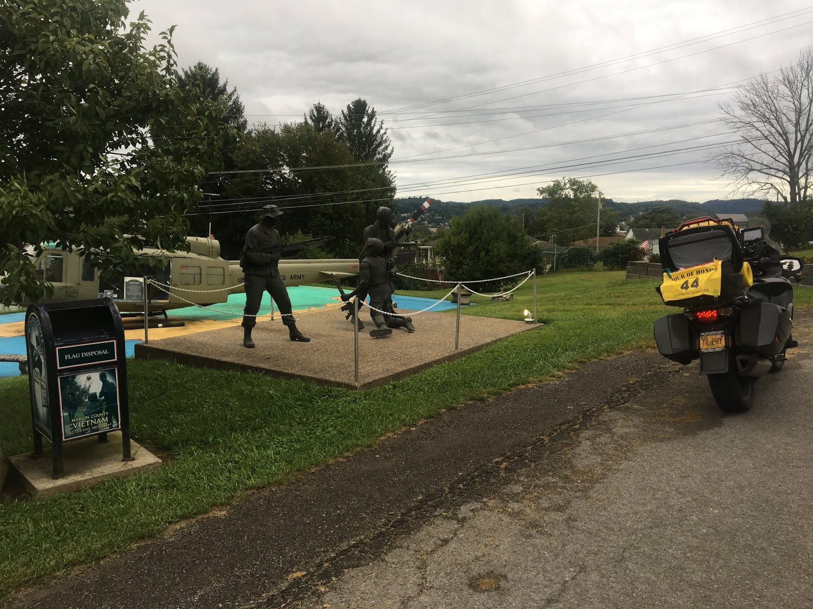
Next up was a run up to Fairmont, WV to the memorial park there.  This park has been a source for several years worth of bonus locations.  Fortunately, it is right off the Interstate and easy to get to.  This particular bonus shot is worth a couple of points. First is the WV2 bonus but this year there are also bonus for pictures of real UH-1 (Huey) helicopters.  This one in particular actually did fly in Vietnam and was included here in the memorial gardens.

Turning south I followed pretty much the same path run during two earlier rallies this year.  US-19 provides a more direct north-south traverse of the state than the Interstates and my next bonus was located in the small town of Summerville.  As luck would have it, Summerville was hosting its 50th Annual Potato Festival and my bonus location was right in the middle of it. After circling around town a few times I finally located a back way where I could approach the bonus. Since we need to have our motorcycle in the picture, this stop required 2 shots.


Continuing down to Beckley I picked up the WV Turnpike as I headed further south to the town of Princeton.  The WV4 bonus is located on the West Virginia Welcome Center grounds just off the Interstate.  After claiming the bonus, it was time for some lunch. In a rally situation I wouldn't consider a sit down lunch but I knew that I had some extra time to complete the SS1000 so I pulled into the Wendy's nearby.  OMG, this had to be the slowest Wendy's in the world.  It took over 20 minutes to get my "fast food". Grrr.

Turning back north it was back on the WV Turnpike for a dash to Barboursville which is in the far west side of WV near Huntington.  My next two bonuses were daylight only locations so I needed to beat the sunset.  Fortunately, the WV Turnpike between Berkley and Charleston might as well be a public race track as drivers, cars and trucks alike, put the pedal to the metal and roll through on the curvy, mountainous path.

Arriving in Barboursville in the late afternoon, I made my way out to the city park where the bonus was located.  The park was magnificent.  I was truly impressed by how nice it was laid out on the banks of the river.  The bonus itself, WV1, was located next to a small lake and is probably the most touching of all the designs.  I understand that it is one of a series that are being installed across the nation.  It reminds us of what is important in our country and drives home the sacrifice that our military members and their families make to keep us free.  The empty outline is for the service members that make the ultimate sacrifice.  God bless them.


The next West Virginia bonus is nearby in Point Pleasant, however, a small diversion into Ohio will allow me to capture an available bonus.  So across the Ohio River I go and make my way a little further west to South Webster, OH, to location the OH6 bonus.  By now I had finally moved into the rain that would plague me the rest of the ride.

 Now on some back roads of southern Ohio, I was getting a bit concerned about the slower pace.  Heading towards Point Pleasant I passed by the corporate home of Bob Evans of sausage and breakfast restaurant fame. There's a bit of history between my family and Bob Evans Foods.  In 1987, Bob Evans acquired Texas-based Owens Country Sausage which was founded by my great uncle Clifford Owens.  So I get a smile when I roll through nearby knowing that there's still a bit of Owens in the Bob Evans company.

Arriving back in West Virginia at Point Pleasant a notion that was building all day long was reinforced in spades, West Virginia will build a bridge.  If you have a 20 ft wide creek, West Virginia will build an 800 ft long span 100 ft in the sky to cross it.  My goodness, there are a lot of big bridges in that state.  Sandwiched between a couple of big bridges is the Battle of Point Pleasant Monument (WV3).  It's a wonder that it is still standing given that it is on the river side of the massive levee wall just to the right in the photo.

My last West Virginia bonus was just north of Parkersburg but to get there it was better to go back across one of the massive bridges spanning the Ohio River and continue north through Ohio.

At the Williamstown Welcome Center is a memorial to Fallen Highway Workers and is the WV7 bonus.  This completed my tour of West Virginia but I still needed a couple of hundred miles to complete my SS1000.  Under the Tour of Honor rules, if you capture 4 of the bonus locations within a state while on a SS1000 run, it counts as a Tour of Honor SS1000 and you get a special certificate. If you capture all 7 bonus locations, then you qualify for the Tour of Honor Extreme SS1000.  Over the years that I've been doing the Tour of Honor, I believe that this will be my 13th or 14th Extreme.

Reentering Ohio at Marietta I made my way to Lowell as the sun is starting to set.  Arriving at the bonus I noticed a small yellow rock on the monument.  I don't know the whole story behind it but apparently some veteran riders have been leaving small, yellow numbered rocks at the locations that they visit as an additional honor to those who had fallen.  You can see the rock at the base of the 'V' just below the winged artwork.

The rain was picking up as I looked over my route to the next bonus located north of me.  I needed to get back to Interstate 77.  The two Garmins said to take Cat Creek Rd so I followed the magenta line.  When will I ever learn.  It was 7 miles back to the interstate and I watched as the counter steadily reduced its value.  Not 3 miles in the pavement disappears and I'm on wet hard packed gravel.  Garmin got me again. The next 3.5 miles were done at about 15 mph as the wet surface had just enough mud on top to make it interesting.  I believe that if I didn't have the car tire on the back of the Trophy that I would have never made it out.  It was dark by the time I reached pavement again and made my way to the on ramp of the interstate.  This about drained all my energy that I had counted on to finish the run.  However, getting back up on the highway allowed the stress to fade despite the increasing rain.

In a good way I'm glad that the Garmins saw fit to route me up I-77 to I-70 eastbound as I needed to pick up a bonus on the Ohio-Pennsylvania border town of Bellaire.  Now pitch black outside in a driving rain storm, I took the exit for Bellaire and proceeded to head towards downtown.  Little did I know at the time the Garmins had done me in again.  If the Garmin GPS doesn't have a speed limit in their database for the road, it assumes that it is 55 mph.  This often results in a route that it calculates as faster but it is not even remotely the optimal route.  In this case, I could have traveled 2 miles further down the interstate to the next exit and traveled on main thoroughfares to my stop.  But Noooo, Garmin sends me in the back door of the town where a treacherous set of switchbacks drop you down into the river basin.  It would be bad enough in the daytime.  And dry.  But now in the dark and driving rain, it was a nightmare.  Fortunately, I made it to the downtown park and snapped my photo of the OH6 bonus.

Now a bit wiser I followed the overview map provided by Copilot GPS on my iPad to quickly get me back out to I-70 where I would head back west.  The rain was coming down pretty hard and it was forcing me to keep my speed down a bit.  This was going to take longer than I wanted.  Now back to I-77 I took a quick exit and proceeded into downtown Cambridge for my next bonus, OH2.  This one was not very well lighted so apologies for the fuzzy picture.

One more stop to finish up for the night.  Heading back out to I-70 I made for Columbus, OH where I would turn north on I-71 to make my way to Sunbury for the OH7 bonus.  Arriving around midnight at the bonus location, I'm met with the job dropping visual of hundreds of lighted crosses in a field representing the fallen in the War on Terrorism.  As I approach the memorial to capture my photo, I notice a person with a rifle paying honor and respect to those that had fallen by marching to and fro in the same manner done in Washington, DC at the Tomb of the Unknowns.  I just had to stop, place my hand my hand over my heart, and shed a tear to the beauty and dedication of this man's effort to honor the fallen.  It's pouring buckets at this time. It's cold.  And he is taking his time in the middle of the night to honor and protect this memorial.  Thank you, sir.


By now I have my 1000 miles under my belt but I need to stage for tomorrow's ride so I make plans to overnight a bit further north. Booking on Hotels.com I located a Country Inn & Suites in Mansfield for the right price and make the reservation.  Needing a finish receipt, I headed out to a gas station to get the receipt and stop the clock.  Final tally,  1053 miles in 20 hrs and 40 minutes.  Pitifully slow by rally standards but I certainly did not ride this at rally pace given the really poor weather conditions.


 Here's the final route:


To wrap up I searched my Garmin for the Country Inn & Suites in Mansfield and it popped right up.  So course laid in I made my way up the road.  Pulling in to the hotel, it has a nice veranda to shield me from the pouring rain so I park and start taking off my rain gear so as to not drip all over the lobby.  I make my way in to check in and the hostess can't find my reservation.  I confirmed that I was in the Country Inn & Suites and she said yes. I asked if there was another one nearby and she said no, not that she was aware of.  Tired, wet and not in a good mood I asked for a room anyway.

Little did I know, and her as well, Country Inn had just purchased a Quality Inn one exit further down the road and this was the one Hotels.com was looking at.  Long story short, I paid for 2 rooms that night.  I collapsed in bed about 1:30 am.


 I had planned on getting up and being ready to rock by 6am the next morning.  I was going to continue up to I-80 and capture the final two Ohio bonus locations before making my way to St Louis, MO for my conference.  This would be about an 850 mile day.  Waking up to the sound of rain hitting the window brought the immediate reply of "f*k it" and I rolled back over in the bed.  Getting up at 8am I had breakfast and got loaded up for the straight 460 mile run to St Louis.  It was still raining but fortunately it stopped about 50 miles west of Columbus.

Arriving in St Louis I ended up with a bit over 1500 miles for the two days (just outside of a BB claim).  The plans for riding down to Texas for a few days and another SS1000 back to Virginia were squashed by work recalling me back to deal with Hurricane Florence.  So Wednesday was the 850 mile run back home with just a smattering of rain along the way.  Turned out the hurricane was a non-event for us in central Virginia. 


Wednesday, August 15, 2018

Butt Lite IX Recap - Epilogue - We've Got The Weenies!

No story would be complete without documenting the voyage home.  Sunday morning Karen and I slept in a bit before staring our day.  Since Karen came to the finish, she went ahead and brought our little utility trailer so that we could load the bike on it and we could travel together back home.  Slipping on some clothes we ventured out to the parking lot to load the bike before getting cleaned up to leave.

The parking lot showed signs of dozens of riders that had already hit the road to their various homes.  I know many had significant treks up into the northeast and was pleased to hear later that everyone made it to their destinations safely.  With the Trophy loaded up and cinched down, we headed back up to clean up and pack.

From Lexington, KY to home in Fredericksburg, VA it is a simple task of hopping on I-64 and driving east as it passes within 50 miles of our home.  A short way down the road we stopped for breakfast, checked the bike in the trailer and continued on our way.  Passing into West Virginia, Karen and I simultaneously remembered that we had planned on a visit to Hillbilly Hot Dogs which is just off the Interstate in Lasage, WV.


The Hillbilly Hot Dog compound is quite a sight to behold. A pickers treasure trove.  At the main building the line usually stretches outside. As you make your way in, you are greeted at the ordering desk with a smile.  If you tip the employees sing the Weenie Song.  The menu is quite extensive and the food was really good.  Hillbilly Hot Dogs has been featured on Diners, Drive-Ins and Dives.

West Virginia Table Decorations
School Bus Dining Areas
Hillbilly Wedding Chapel
For Marry'n Relations
Darth Billy
A Look Around


Lastly, I'd like to thank the folks at Team Strange for hosting this event.  The staff and the volunteers are awesome. Simply awesome.  I can't thank you enough for the experience.

It was good seeing friends in the LD community. Steve Gallant, Rick Armour, Gerry Arel, it was great hanging with you guys.  Martin and Lisa, you know that I admire your father/daughter relationship.  It is something that I wish I had with my daughters.

Congrats to all the finishers.  This was a tough one for me at least.

Thursday, August 2, 2018

Butt Lite IX Recap - Finish Day


RC4_6537
Credit: Rick Corwine


RC4_6552
Credit: Rick Corwine
Waking at 4:00 am, I slid on some thankfully fresh clothes that Karen had brought with her, collected my scoring materials and stuff, and sauntered off to the scoring room.  Now I know that you have to get up really early in the morning to get an upfront spot in line.  It seemed like all of the early arrivals had also made their way down for scoring.  There was a breakfast area set up in the next room where some of the late arrivals were getting their scoring materials together.  I decided that the line was going to be what it is and headed over to the buffet.

My buddies, Steve and Rick, were there diligently working on their prep, both having just arrived in the wee hours.  Looking up I see Jim Owen walking in with gear, helmet on, and bags. I have to admit that I wasn't quite ready to see the obvious wear that the road had taken on him. Jim Owen having the meat-on-a-stick look?  That just doesn't compute.  A few minutes later I was in the buffet line next to Jim's lovely partner in crime, Janet, and she confessed that she had never seen him coming looking so roughed up.  I take solace in knowing that this rally took it's toll on everyone, even the biggest of the big dawgs.

A while later I get my turn and am ushered into the scoring room where I had over my camera SD card and the contents are copied off to my rally pack thumb drive.  I only have to wait a few minute before a scoring table opens up.  I sit down across a really special lady, Minna Case. Minna was the only female participant in the NotSuperman Coast to Coast ride that I did in 2016.  She piloted her "Tigger" from Coney Island, NY to the Golden Gate Bridge, CA, a distance of just over 2900 miles, in under 50 hours. Known offically as the 50CC Gold, it is also known as the 50CC The Hard Way.

After catching up for a few minutes we got down to business.  I handed over my receipts, my purchases, and my mug.  Minna started her process of reviewing my claimed bonuses.  Thankfully all my photos made it this time.  After scoring 7-8 bonuses, Minna sat back with a quizzical face and called over the Rallymaster.  Sure enough, the date set on my camera was off.  Bitten by the new camera bug again!  100 point penalty.  Thankfully that was the only issue with scoring this time around.

Leg 2 point total came up to 10793.  When combined with Leg 1 score of 7528 I ended up with an overall score of 18321.  Looking at the official standings, my placement would not have changed appreciably if I had bagged many more bonuses.  Total official mileage was 4707 which is about 1000 less than what I had expected of myself.

With all the business stuff taken care of and a few more hours of sleep, I took the opportunity to practice my UAV flying as I have recently obtained my FAA Commmercial Remote Pilots License.  Below is a sample which is a flyby of the reserved parking for all the BLIX participants.


Later that day we settled in for happy hours and the finishers banquet.  I'm pleased to hear my name called up for 54th place which was an improvement of 15 places over my Leg 1 placement.  I had set a goal of placing in the top 30.  Had I not lost the stadium combo I would have finished in the top 20.

As the scores are continuing to be announce in reverse order, my buddies Steve Gallant and Rick Armour were seated at the table with me and they still hadn't been called yet.  The carrot here is that if you place in the top 10, you are automatically invited to participate in the Iron Butt Rally the next year.  The unluckiest place is #11 and it falls to another friend, Jay Bolinger.  He graciously accepted his finishers plaque with a smile but I knew that he had to have been crushed inside.

Now we've reached the Top 10 and my buddies Rick and Steve still haven't been called.  There was also an unfamiliar face sitting at our table that hadn't been called either.  Places 10-6 are called and all three are still sitting.

Steve is called for 5th place.  He had ridden all the way up to Maine and the VT/Canadian border in the 2nd leg including ridding up Mt Washington.  For an enjoyable read, check out Steve's blog at Swerve Northeast.

Rick is called for 4th place.  Rick had ridden a similar plan to mine for the 2nd leg but in the opposite direction.  Rick and Steve were 9th and 10th respectively at the end of the first leg and both moved up with their epic rides on the second leg.

3rd place went to Eric Bray.  Eric was the first IBR finisher that I had ever met so it was great to see him do so well again.

The unfamiliar gentleman sitting at my table still hadn't been called.  He and Jim Owen were the only riders left.  When 2nd place was announced, it fell to Billy Connacher.  This meant that the victory had gone to Jim Owen.

RC4_6830
Credit: Rick Corwine


Wednesday, August 1, 2018

Butt Lite IX Recap - Day 6 - Revenge of the Time Suck Bonus

After maximizing my rest bonus, I was eager to get started for the last day of the rally.  I hadn't planned for an all out max effort today but rather to just finish safely.  My goal was to roll into the finish around midnight into the waiting arms of my bride. Getting all my gear together and my riding clothes on, I headed out to load the bike only to be greeted by the nice couple from last night and several others who had encircled my bike.  Trying to chat while loading up finally gave me some perspective on the whole 'spectator at the bonus' thing I see posted occasionally.  I headed back in for some breakfast and walked into a room packed with all the Women's Rally group.  I felt really self-conscious because my riding gear was on its 6th day of funk accrual but I had no choice.  I'm pretty sure that I looked like meat on a stick by then. Probably smelled like it, too.  After securing my check-out receipt and confirming the timestamp, it was time to make haste and get on the road.

First up was the Roan Mountain bonus (RON) located at the Carvers Gap turn out located on the TN/NC border.  The Gap is at 5512 ft so this was going to be highest climb of the rally.  On the way I encountered the only respite of rain during the entire week.  Nice to have the windshield cleaned a bit.  Turning off of US19E onto TN143, the area was what I dream about for retirement.  Moderate valleys surrounded by mountains, bliss.  I must have been lost in my thoughts of retirement as I blindly made a turn that the Garmins had indicated.  Horse farms and pastures lined the road as I made my way up the mountain.  The little magenta lines squiggling their way forward as the roadways became narrower and narrower.  I'm snapped out of my dreamland as I ride up to a near vertical gravel goat path and stop.  I look down at the Garmins and they insist that I continue straight ahead up the near sheer wall in front of me.  Damn.  I pull out the rally book and it says the bonus is on NC261/TN143 at the border. Key phrase "on NC261/TN143". Why did I not stay on the highway?  The blue line shows the Garmin route through the valley as it thinks all the roads are 55 mph.  The red line is the highway route which is signed at 40 mph so Garmin thinks the blue line is the fastest.  So my wasted 10 minutes of daydreaming up the valley.  Another 10 to get back to the highway. And another 10 to get back up to the previous point. Yeah, that was a 30+ minute time suck.  It is my understanding that a lot of riders got bit by this bonus, including the most dominant rider in our sport.


A short distance away was the Wilson Creek National Wild and Scenic River bonus. The ride in to the Visitors Center included a trek up a 3 mile hard packed but potholed gravel road (Garmin thinks it is a 55 mph road, btw).  The river gorge was certainly beautiful and I could have stayed right there for the rest of the day.  As I was having to keep my speed down on the way in and again on the way out, I lost another 20+ minutes as compared to what Garmin expected.  Making the checkpoint by midnight was looking more and more less likely.

The next bonus was probably less than 3 miles away as the crow flies but required a 15 miles trek down, over and back up to reach it, again along a slow gravel road.  The Collettsville Cup House, aka The Mug House, is just one of those Americana things you just have to see to believe. It is a small house and a camper sitting beside it with all of the exterior surfaces (excluding the roof) covered in coffee mugs.  Even the low split rail fence surrounding the property is covered in mugs.  Our requirement here caused a lot of riders to be sad.  When we registered at the beginning of the rally the previous Friday, we were handed a swag bag that included shirts, stickers and a coffee mug.  After countless questions and evasions, the Rallymasters relented and said that we would not need our swag bag contents on Leg 1.  This prompted a lot of riders to leave their bags at the rally hotel storage only to learn that on Leg 2, this bonus would require the mug to be in the photo.  Many didn't find this out until they were sitting here in front of the house with their mugs in Lexington, KY.  Luckily I had brought my bag with me including my mug.  The mug had to be intact and also presented at scoring.


So now that I've ventured up my 3rd significant time suck of the rally, I'm running nearly 2 hours behind schedule. It's time to turn for the barn and pick up bonuses along the way.  I'm starting to feel the tug of going straight to the finish but resist and continue collecting bonus points.  Next up is the Buffalo Mountain (BUF) bonus up on the Blue Ridge Parkway near Floyd, VA.  I'm somewhat familiar with the area as one of our favorite winery stops, Chateau Morrisette, is nearby.

It was about a 3 hour run to the bonus. With the temperatures rising again, it was nice to get up on the ridgeline for a while and enjoy the cooler temps.  This was another question/answer bonus asking about what activity was done on the mountain for more than 50 years.

Just a few miles up the BRP at Tuggle Gap is a small inn, restaurant and gas station (very expensive I might add).  I needed some gas so I decided while stopped I would go ahead and grab a burger.  Lots of motorcycles stop here so service was a bit slow which cost me more time than I had wanted but the nourishment was welcomed.

The next bonus was at the Booker T Washington National Monument up near Smith Mountain Lake.  I had passed it a few times on other rides so I sort of knew the general direction.  My better judgement said to get off the BRP on SH8 east to connect with SH40 north.  Buuutttt, the Garmins said go north on the BRP. I did as the magenta line said and watched the clock tick away. I finally made the call to exit near Ferrum down a county road and that was another major time suck.  I even caught up with a State Police Trooper trying to make his way hastily down the mountain as well. Tick. Tick. Tick.  Frustrating.  The country roads making my way up to the lake were somewhat crowded and it just seemed like everything was conspiring to slow me down.  Grrrr....  Finally, after what seemed like an eternity, I pulled up to the BTW bonus and captured it.

Heading out for the Appomattox bonus, it just didn't feel like I was going in the right direction.  I stopped and checked my iPad and yes this was the right way.  Pulling into the outskirts of Roanoke, VA, I turned east on US460.  This is weird.  I know Appomattox is another 60 miles east of here but is there something here associated with it?  Pulling off the road and following the magenta line through a single lane RR underpass, dodging rock hauling trucks, I finally pull up to a gated gravel road right where the gps marker is located.  Hmmm...doesn't seem like the right place.  I pull out the rally book and punch the printed coordinates into the iPad and, sure enough, it comes up in the right place 60 miles to the east of me.  I was about to call the Rallymasters when I checked the electronic files and noticed that the coordinates were not the same as those printed in the rally book.  Since I knew that I was not going to waste 3 hours to bounce over for the APP bonus, I didn't bother calling the Rallymasters.  Another chunk of time suck added.

A bit miffed I turn my attention to heading west back into West Virginia.  The Garmins had me heading out to I-81 and heading south to Blacksburg. Being a Friday afternoon, I-81 was packed with semis going about their way.  Thankful to exit off on US460 I make my way through some beautiful landscapes over into West By God Virginia.  I arrive in Talcott mid-afternoon as some sort of town carnival/festival is about to kick off.  The band is warming up.  Booths are just wrapping their set up.  And here goes a funky smelling fat bumblebee trotting across the grounds over to the bonus location.  As I approach 2 other riders are there taking a water break. I highly recommend taking a few minutes to read about the legend of John Henry (Wiki John Henry Folkore). I chat for a few minutes, take my photo and start my trek back across the grounds to where I was forced to park.  By now I definitely have that meat-on-a-stick look going as a local firefighter walks up and checks on me, offers me some water, and invites me into their cool tent.  I thank him for the water but decline the stay as I need to get going.  I have a time restricted bonus to capture and it's getting late.

Heading for the Hawk's Nest Tunnel Disaster (HWK) bonus, I finall overrule the Garmins as I know the route that they are suggesting will absolutely wear me out with the twisties.  I hop on I-64 to Beckley before turning north on US19.  I arrive at HWK as the sun is touching the horizon.  A short trek down the path is the interpretive marker that is the bonus.  This area overlooks the New River Gorge and is so inviting to just spend a while but, alas, I need to move on.

Getting back to the bike a quick check of the Garmins reveal about a 3.5 hour (218 miles) ride back to the finish.  Satisfied with what I accomplished, I made the call to head straight for the barn. With the pressure off of collecting bonus, I enjoyed the 40 or so mile riverside ride on US60 before joining back up on the I-64 slab heading to Lexington.  As darkness set in the traffic thinned out, the temps lowered, and I could really relax and reflect over the course of the rally.  Remembering that this was a learning experience and that is the takeaway that I need to focus on.  Mistakes were made but learning from them was the most important thing.

I've ridden through Huntington, WV several times at night heading westbound.  It is truly a spectacular site when you pass through a small gap in the mountains at the Kentucky border and are dazzled by the lights coming from the large Marathon Oil Refinery complex across the river.  It's beautiful in its own way.

Watching the Garmins count down as I neared the finish, it was satisfying to take the exit and pull up behind a couple who were finishing their ride as well.  Pulling into the parking lot I spot Karen waiting for me and it brings tears to my eyes. I've accomplished my #1 goal of the rally, making it back to her.


I park the bike in our reserved area and take a deep breath.  I've done it.  Not the way that I had envisioned but I was done with my first major multi-day rally.  That was satisfying.  The Dezl GPS tells the tale of the tape.  4765 total miles with 2061 on the second leg.  That would have 2704 on the first leg.  My Trophy's ODO reads somewhat slow so my official mileage is lower at 4707 miles.


Fat Boy Done Rollin'
Karen helps me unload and we head up to the room.  A nice loooong shower is welcomed and I sit down for a while to prep my scoring sheet.  Scoring opens at 4:30 am and I'd like to not have to wait too terribly long.  Being my first rally, I have no idea how many folks are going to be in line.  Time for some rest.

Of the planned 4161 points for today, I settled for collecting only 2562.  That's OK.  I have my Lessons Learned to be satisfied with.

Final Scoring and Wrap-up continued...


Tuesday, July 31, 2018

Butt Lite IX Recap - Day 5 - Rejuvenation

Day 5 (July 12) started in the wee hours after a good 8 hour break. The hotel host was fantastic in helping me get ice and fresh water in my hydration jug and an apple to get me going.  Unfortunately, since I had booked my stay through Hotels.com (Expedia), he said that he couldn't print me a receipt.  Geez...another receipt challenge.  Rather than waste time as I was unsure of my rest start documentation, I set out to find the 24 hr McDonalds I spotted on the maps last night.  Slamming a couple of McGriddles in my jacket pocket and putting my receipt away, I set out heading back east.

My revised plan was not going to score me big points but it would keep me busy for the next two days.  Today I would cross back through Kentucky entering Virginia and finally stopping for the night in Johnson City, TN. This would set me up for a nice ride to the finish on Saturday.


Into the rising sun I traveled on Illinois SH13 until crossing into Kentucky on SH56.  Thank you, Lord, for the noticeably cooler temperatures.  This is going to be a good day.

Slogging past the maze I encountered yesterday trying to get out to this highway, I passed into Kentucky and swung around Owensboro where, surprisingly, I then crossed over into Indiana.  The ELC bonus was a memorial to the passengers who perished aboard a Lockheed Electra in 1960.


At this point I was coming alive again rejuvenated by the cooler temperatures. Passing back into Kentucky is was short work to make my way back down to the Mammoth Cave National Park and my next, and arguably, the most unique bonus of the rally.

The Green River Ferry is touted as the shortest ferry ride in the world.  Linking parts of the Mammoth Cave National Park, it is maintained and operated by the Park Service.  A maximum of 2 vehicles can fit on it at any one time.  While the Rallymasters allowed us to take a picture of the ferry while waiting (motorcycle, flag and mid-river ferry had to be in photo), we had the option of taking a picture of your motorcycle ON the ferry while crossing.  It was quite the challenge to park, hop off the bike, pull out the rally flag and camera, snap the picture in the middle of the river, stow everything back, and remount the bike to be ready to exit all in the span of about 60 seconds.


Some of the many Barrel Houses at Heaven Hill Distillery
To say that Rallymasters have a devious, sometimes cruel streak is somewhat of an understatement.  Had they know how much I love whisky, they would not have included the next bonus.  In Bardstown, KY is located the Heaven Hill Distillery where several brands are produced including Evan Williams and Elijah Craig (YUM!!).  Our task was to purchase an item from the visiter center and have the item and receipt presented at scoring.  I purchased a small container of Evan Williams Smoke Garlic Salt for the rally and a bottle of Elijah Craig Small Batch (94 proof) for myself.


Next up was the WLD bonus located in the Daniel Boone National Forest.  This proved to be one of the most challenging bonuses to collect.  The rally book clearly states that the last 2.5 miles to the bonus is a "narrow, one-lane gravel" road.  Apparently, Garmin didn't get the message.  In the map shown from Garmin's Basecamp route planning tool, my arrival to the area was from the NW (upper left) corner (follow the red line).  After passing through the small town of Livingston, the Garmins emphatically tell me that I missed the turn.  I'm thinking what turn? I didn't see a road.  I u-turn and go back to the point where a small, and I mean almost unnoticable, gravel road heads down the trail to the river.  Ok, we are supposed to take a gravel road to this bonus so there I go.  It becomes very apparent very quickly that this ain't going to go anywhere but straight into the river!  Later I learned that there was once a low water crossing at this location but it had been washed out decades ago, however, the County still has it recorded as a county road.  Garmin interprets it as a 55 mph road.  With no room to turn around on the downhill road, I am forced to go all the way to the waterline before I can attempt a turn around.  Parts of the 20 point turn had my rear wheel slipping into the river.  I'm not amused at this point.  F*n Garmin.  ***somewhere in the back of my mind is the mantra, Don't Always Follow the Magenta Line.***

Escaping from this trap I stop at the highway and fire up the iPad and CoPilot to get my bearings.  I see an alternate approach (blue line) to the bonus a little further to the south so I take off that way.  Sure enough the Garmins pick up the change and route me properly to the bonus which is the Camp Wildcat Battle Monument.  The last 200 yards into the bonus is nice, fresh asphalt leading to a new looking monument area. Our task was to answer a question from one of the interpretive signs.  Done.  Now looking at the Garmins, I see that they are trying to route me out in a direction that simply does not exist!  Being a little wiser at this point I head out the way I came in and would deal with the rerouting once on the highway.  This bonus cost me about 45 extra minutes that I really didn't have that day.

Thankful to still be upright, I headed off to Jackson, KY for my next bonus, a historical marker dedicated to some really angry people following the Civil War.  The marker states that probably around 100 county officials were killed in the time between 1870 and 1920.


Continuing my eastern trek the next bonus was fortunately right on my path and was easy to get to.  The Battle of Middle Creek where a young Col. James Garfield would elevate his stature by leading his Union troops to a victory over the Confederates of eastern Kentucky. This event launched Col Garfield on his path to the Presidency of the United States.


The next bonus was special in a personal way.  If you recall the TV mini-series "The Hatfields and McCoys", the feud between the two families started with the trial of Floyd Hatfield for stealing one of Randolph McCoys' hogs.  The trial was presided over  by Judge Preacher Anderson Hatfield. Long story short Floyd Hatfield was acquitted and everything spiraled out of control from there.  My In-laws were raised in nearby Williamson, WV and some family had married into the McCoys.  Our bonus was to photograph the Hog Trial Site marker located at the log structure where the trial was held.

Heading south on US 119 through the long ridges of the middle Appalachian Mountains the roads became decidedly more twisty.  While a whole lot of fun to ride on, they don't really help when you're on the clock in a rally.  Passing through Pikeville and Cumberland, KY, I finally reached the turn off to Lynch, KY where my next bonus was located.  Lynch was a company town where the coal mine owners owned everything, including the housing.  Workers had to "rent" housing from the company, purchase food from the company store, etc.  Even the local police force was run by the company. Their main job was to deal with workers trying to unionize the mine.   The bonus,  P31, was to take a picture of the Portal 31 entrance to the mine which is now a tourist attraction.

The Trail of the Lonesome Pine
My last bonus of the day was a mere 18 miles away in Big Stone Gap, Virginia.  However, it would take nearly an hour to traverse the ridges on the way.  The route is known as The Trail of the Lonesome Pine and it lives up to its name.  It seems like you are hundreds of miles away from civilization.  Beautiful but isolated and a major time suck.


Arriving in Big Stone Gap I collected my bonus and started looking for some hotel options.  I was going to be able to make it to my planned stop in Johnson City, TN but would be a bit behind schedule.

I needed to make sure that this was an 8 hour stop in order to maximize my rest bonus points.  I just was not confident that I had good receipts from last night so I made sure that I got good ones tonight.  The clerk at the Best Western gave me a check-in receipt that had the proper timestamp on it and he assured me that the check-out would also have a good timestamp.

After lugging my gear up to my room I ventured down to the attached Chinese restaurant in the hotel. Risky, I know. But I was too tired to go anywhere else.  As I'm eating my dinner a couple walks up and starts asking me about my bike.  It turns out the hotel is hosting a Women's Motorcycle event that weekend.  They are very nice and quite interested in what I'm doing on this rally.  I do the best I can but I have to finally tell them that I have to get upstairs to bed.

Ah, a shower.  A nice relaxing shower.  Today has been a good day.  I captured everything that I had planned for.  Started my learning on not to blindly follow the _____ magenta line (not entirely learned yet).  I'm asleep before my head hits the pillow.

Points collected today:  3502.  I'm ok with that.

Day 6 coming up...